Alpine Anomaly: Switzerland's Unexpected Return to Winter Amidst Summer
Unpack Switzerland's bizarre summer! Discover why heavy rain, snow, and mudslides are disrupting the Alps, from meteorological causes to crucial safety insights.
A Summer Interrupted: The Immediate Impact
, a nation usually synonymous with idyllic summer landscapes in July, has unexpectedly found itself grappling with a stark meteorological paradox. Instead of the anticipated warmth and vibrant outdoor activities, the country is experiencing a dramatic and unseasonable plunge into cool, wet, and even snowy conditions. This abrupt shift has brought immediate and tangible disruptions across various regions. For instance, 's 'Center Eleven' in Oerlikon reported a leaky roof, a telling sign of the relentless rainfall. The federal government, responding to the escalating situation, quickly raised the danger level from 3 to 4 in several cantons, signaling a serious threat of heavy rain and widespread flooding.
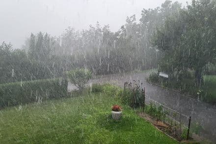
Daily life has visibly transformed. Residents, who might typically be enjoying lakeside swims and barbecues, are now reaching for jackets and umbrellas, a stark contrast to the usual summer scene. The persistent downpours have thoroughly saturated the ground, creating hazardous conditions. Meteo News issued warnings of sudden flash floods in streams, falling branches, toppled trees, hail damage, and lightning strikes, particularly affecting , , and the . Mudslides have already occurred in areas like and on the , tragically underscoring the destructive potential of this unusual weather. Looking ahead, forecasts even include up to 50 centimeters of fresh snow above 2700 meters by Monday, solidifying this bizarre mid-summer interruption.
Behind the Deluge: Unpacking the Atmospheric Dynamics
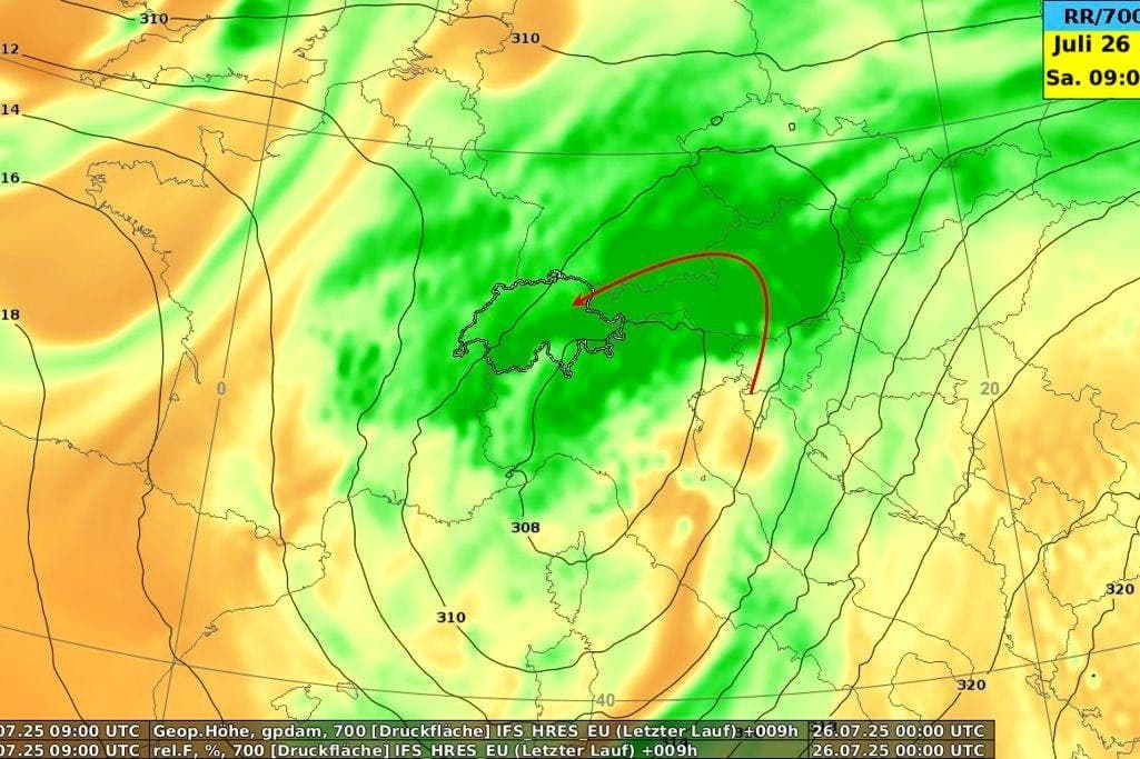
Understanding the atmospheric forces at play provides crucial context for 's current predicament, moving beyond just the immediate effects. At the very core of this 'un-summer' lies an upper-level low-pressure system, strategically positioned over . This powerful system isn't just sitting there; it's actively drawing in moist, unstable air masses from the northeast and channeling them directly towards the northern side of the . Think of it as a massive, invisible conveyor belt pushing humid air right into the mountain range.
As this humid air encounters the formidable barrier, it has nowhere to go but up. This process, known as orographic lifting, forces the air to ascend rapidly, causing it to cool dramatically. When the temperature drops sufficiently, the moisture within the air condenses, forming dense clouds and leading to persistent, heavy rainfall. Meteorologists explain that even slight warming at ground level can trigger air parcels to rise, condense, and generate showers, further intensifying the precipitation. The essentially act like a giant sponge, wringing out the moisture from these incoming air masses and concentrating the deluge on their northern slopes. This continuous influx of moisture combined with the forced ascent creates an exceptionally efficient rain-producing machine, ensuring the country remains under a blanket of grey skies, far removed from any semblance of summer warmth.
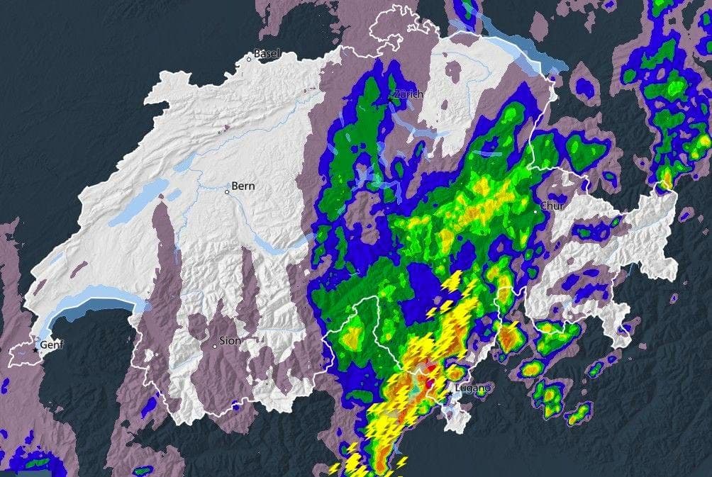
Navigating the Hazard: Risks, Responses, and Safety
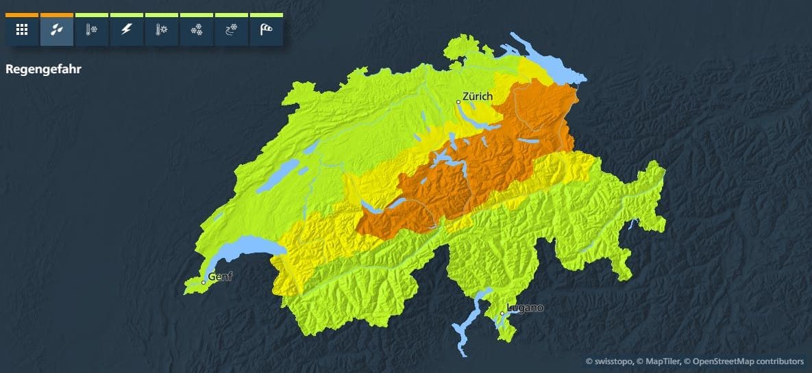
With such intense atmospheric dynamics now firmly established, the resulting hazards demand serious attention and proactive responses from residents and authorities alike. The escalation to danger level 4 across several cantons isn't just a bureaucratic update; it underscores the severe risks of heavy rainfall and widespread flooding. Beyond the obvious inconvenience, people face more immediate and potentially life-threatening dangers. Authorities have issued urgent warnings regarding flash floods in streams, which can swell rapidly and unpredictably, turning tranquil waterways into raging torrents. The ground, already thoroughly saturated, significantly increases the risk of falling branches and uprooted trees, posing a direct threat to property and, more importantly, personal safety.
Perhaps the most insidious danger is the increased likelihood of mudslides, or 'Murgänge,' which have already impacted areas like and the . These powerful torrents of mud, rock, and debris can occur suddenly and without any prior warning, possessing immense destructive potential. Consequently, the strongly advises everyone to avoid riverbanks, lake shores, and especially steep slopes, where the ground is already heavily compromised. Mountain streams, in particular, should be strictly avoided due to the unpredictable nature of mudslides. With expected precipitation levels between 120 and 170 mm, and the snowline dropping dramatically from 3000 to 2000 meters, the period from Sunday afternoon through Tuesday midnight is anticipated to be the most critical phase, with localized thunderstorms potentially intensifying the rainfall further. Staying informed and adhering to official warnings remains paramount for everyone in affected regions.
The Alpine Outlook: When Will Summer Return?
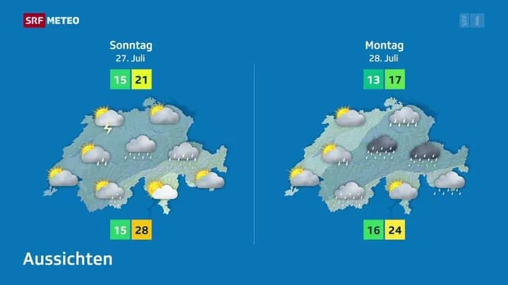
After days of relentless rain and unseasonably cool temperatures, a common question echoes across : when will summer finally make a proper return? While meteorologists predict a gradual improvement, it won't be an immediate leap back into high summer. The most intense phase of this unusual weather event is expected to subside by Tuesday. The lowlands, particularly in the west, might start to see some partial sunshine, but areas along the will likely remain partly to heavily cloudy with isolated showers. The snowline, after dipping significantly, is projected to rise slightly to around 2500 meters, though another 5 to 10 centimeters of fresh snow could still fall above 2800 meters.
The shift away from this anomalous pattern will be slow and deliberate. The upper-level low over , which has been the primary driver of this cold, wet spell, will gradually loosen its grip. While the plains might experience intermittent rain until Monday, interspersed with longer dry spells, the northern slopes, having borne the brunt of the precipitation, will continue to see persistent rainfall. These areas could accumulate between 80 and 130 mm of rain over three days, exceeding half of the typical July rainfall for many locations. Temperatures, currently hovering around 16 to 20 degrees Celsius instead of the usual 25+ for July, will only begin to climb hesitantly from Tuesday onwards. It’s worth remembering that such temporary 'winter intrusions' in the high are not entirely unprecedented in summer, as a similar event occurred earlier in July. However, the prolonged nature and widespread impact of this current spell certainly make it a notable exception.
Related Articles

Alpine Anomalies: How Summer Storms Are Rewriting Switzerland's Weather Story
Alpine Anomalies: How Summer Storms Are Rewriting Switzerland's Weather Story
Switzerland's Wet Awakening: Unpacking a Weekend of Torrential Alpine Fury
Switzerland's Wet Awakening: Unpacking a Weekend of Torrential Alpine Fury
Alpine Fury Unleashed: Navigating Switzerland's Extreme Weather Resilience
Alpine Fury Unleashed: Navigating Switzerland's Extreme Weather Resilience

Italy's Atmospheric Awakening: Navigating a Summer of Unprecedented Volatility