Decoding the Downpour: Staying Ahead of South Africa's Turbulent Weekend Weather
Don't just watch the weather, prepare for it. Unpack SA's Level 2 rain & Level 1 wind warnings. Get ready for a challenging weekend with our essential guide.
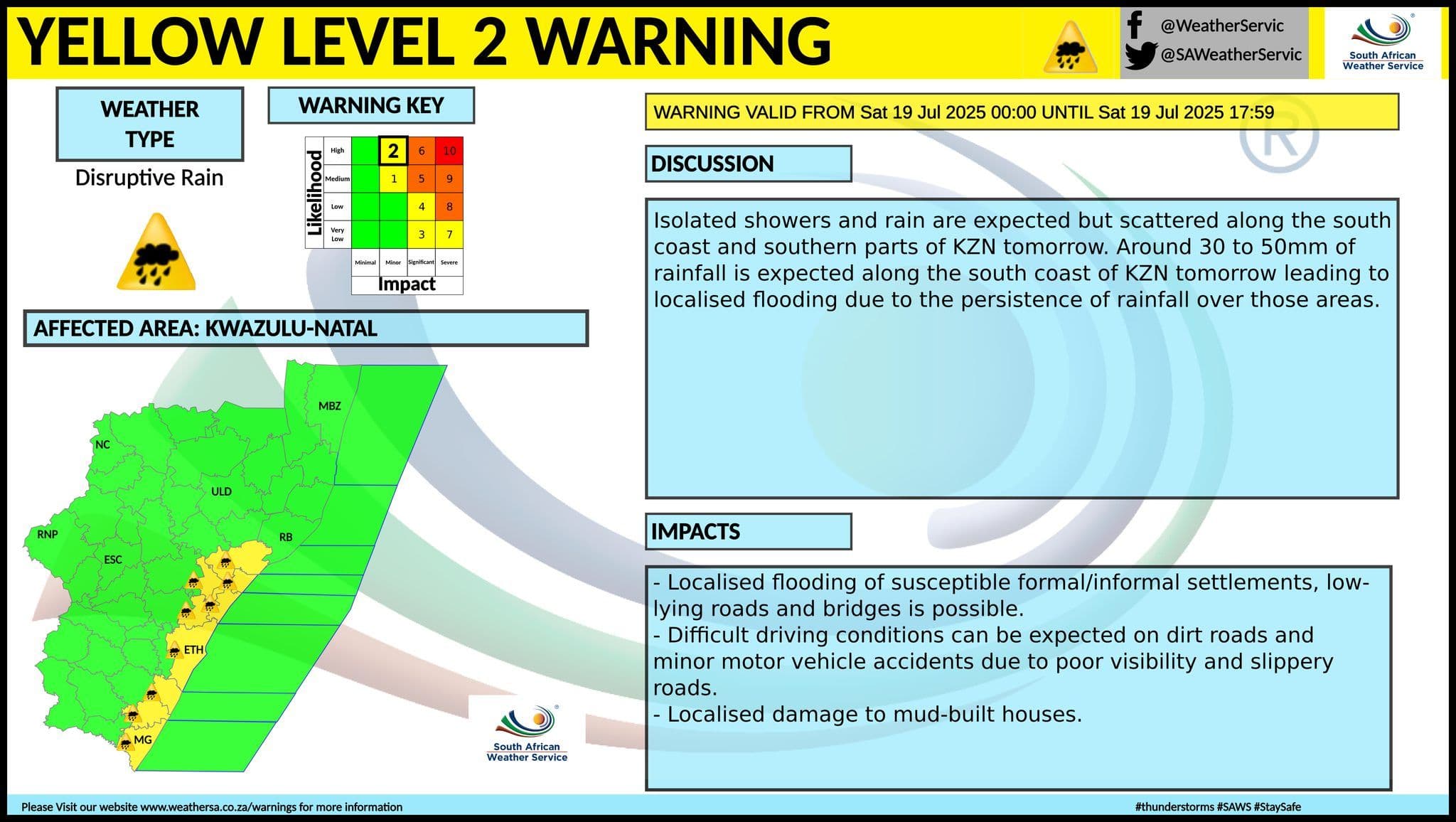
KwaZulu-Natal's Looming Deluge: What to Expect from Level 2 Rainfall
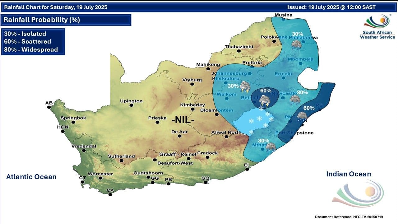
As the weekend approaches, South Africa's east coast is bracing for significant weather, with (KZN) under a Level 2 warning for disruptive rainfall. This isn't just a light drizzle; we're talking about an expected 30 to 50mm of rain along the south coast of KZN on Saturday. What does a Level 2 warning truly mean for residents? It signals a moderate risk of impact, primarily localised flooding. Imagine roads becoming impassable, low-lying areas turning into temporary lakes, bridges submerged, and navigating dirt roads becoming a treacherous affair. The persistence of this rainfall is the key concern, as it allows water to accumulate, exacerbating these conditions.
Specific areas like and are forecast to experience scattered showers and rain, accompanied by moderate to fresh easterly to south-easterly winds. , further inland, will also see morning fog patches giving way to scattered showers. This isn't merely an inconvenience; it's a call to action. Understanding these specifics helps residents prepare for the potential disruptions to daily life and travel, ensuring they aren't caught off guard by the sheer volume of water expected to descend upon the region.

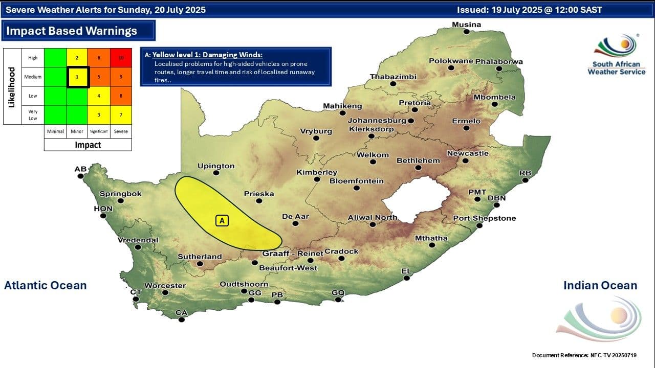
The Northern Cape's Gusts: Understanding Level 1 Damaging Wind
While KZN grapples with heavy rain, the shifts focus to a different kind of weather threat: damaging winds. A Level 1 warning for wind is in effect for parts of the Northern Cape on Sunday. Although a Level 1 warning indicates a lower impact risk compared to KZN's rain, it's crucial not to underestimate the potential dangers. 'Damaging wind' at this level can still cause significant disruption, from blowing over unsecured outdoor items like garden furniture and refuse bins to making driving conditions hazardous, especially for high-sided vehicles.
For Saturday, the Northern Cape is generally expected to be fine and cool to cold, with warmer conditions in the north-west and moderate to fresh easterly to south-easterly winds along the coast. However, the shift to Sunday brings the increased risk of stronger, more impactful gusts. This highlights the varied nature of the weekend's weather across the country; while one region battles water, another will contend with the force of the wind. Being aware of these distinct threats allows for tailored preparations, ensuring safety is prioritised for each unique challenge.
Beyond the Warnings: A Snapshot of Regional Conditions
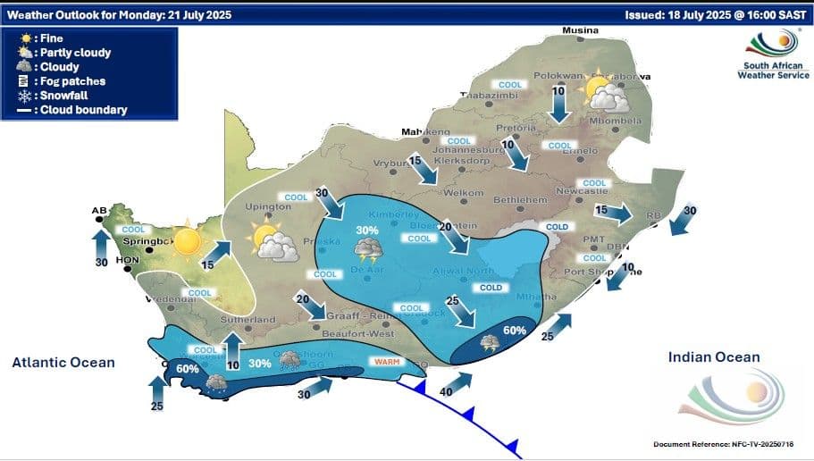
Beyond the specific Level 2 rainfall warning for KwaZulu-Natal and the Level 1 wind warning for the Northern Cape, much of will experience a mosaic of conditions this weekend, underscoring the country's diverse climate. The interior, including , , and parts of , will generally be cool to cold. Gauteng is set for partly cloudy skies with light rain clearing by evening, while Mpumalanga's escarpment will see morning fog and isolated showers, transitioning to warmer conditions in the Lowveld. Limpopo anticipates drizzle along its escarpment, remaining cool, but warming up in the Limpopo Valley.
Further south, the and can expect partly cloudy and cool conditions, with isolated to scattered showers and thundershowers, particularly in the eastern parts of the Free State. The will largely be fine, cool to cold, with morning fog patches over northern high ground. The presents a split picture: the western half will be fine and cold, while the eastern half will be cloudy and cold with isolated to scattered rain, especially along the Wild Coast. This broad overview emphasizes that while some areas face severe warnings, cooler temperatures and isolated showers will be a common theme across many other regions, demanding general preparedness.
Your Proactive Weather Action Plan for the Weekend
With the issuing warnings and varied regional forecasts, being proactive is your best defence this weekend. For those in KwaZulu-Natal, particularly along the south coast, where Level 2 disruptive rainfall is expected, prepare for localised flooding. Secure loose outdoor items that could be swept away, avoid crossing flooded roads or bridges, and if driving, be extremely cautious, especially on dirt roads where conditions will be challenging. Consider postponing non-essential travel in affected areas.
In the Northern Cape, under the Level 1 damaging wind warning for Sunday, ensure all outdoor furniture, trampolines, and other light objects are secured or brought indoors. High-sided vehicles and motorcycles should exercise extreme caution on open roads, as sudden gusts can be dangerous. For the rest of the country experiencing cold snaps, fog, or isolated showers, remember to dress warmly in layers, check your vehicle's tyres and lights before travel, and be mindful of reduced visibility due to fog. Having an emergency kit ready, with essentials like blankets, water, and a charged phone, is always a wise move. Your preparedness can make all the difference in navigating these challenging conditions safely.
Staying Informed: Essential Resources for Real-Time Updates
Navigating turbulent weather requires more than just initial preparation; it demands continuous vigilance. Weather forecasts, especially during periods of severe conditions, are dynamic and can change rapidly. The information provided by the is the most authoritative and up-to-date source for conditions across South Africa. They frequently update their forecasts, sometimes multiple times a day, to reflect the evolving meteorological situation.
To stay ahead, make it a habit to check official SAWS channels regularly. This includes their official website and any dedicated mobile applications they may offer. Many news outlets and weather-focused platforms, like the one this forecast originates from, also provide integrated SAWS updates, often including convenient formats such as daily podcasts. Beyond official forecasts, listen to local radio broadcasts for immediate community-specific alerts and traffic updates. Following reputable emergency services on social media can also provide real-time information on road closures or safety advisories. Being plugged into these essential resources ensures you have the latest information at your fingertips, empowering you to make informed decisions and keep yourself and your loved ones safe throughout the weekend.
Related Articles
Coastal Deluge to Inland Chill: Navigating South Africa's Weekend Weather Gauntlet
Coastal Deluge to Inland Chill: Navigating South Africa's Weekend Weather Gauntlet
The Unpredictable Canvas: Weekend Weather's Regional Stories Unfold Across South Africa
The Unpredictable Canvas: Weekend Weather's Regional Stories Unfold Across South Africa
Winter's Shifting Canvas: Unpacking South Africa's Diverse Cold Front Experience
Winter's Shifting Canvas: Unpacking South Africa's Diverse Cold Front Experience
Unveiling Winter's True Face: South Africa's Next Cold Front and Its Ripple Effect