The Paradox of August Skies: How Tokyo's Scorching Heat Ignites Sudden Deluges
Kanto's summer paradox: Extreme heat fuels sudden, intense rain. Uncover the science of these cloudbursts, their urban impact, and crucial safety tips for unpredictable skies.

The Unseen Engine of Summer Storms
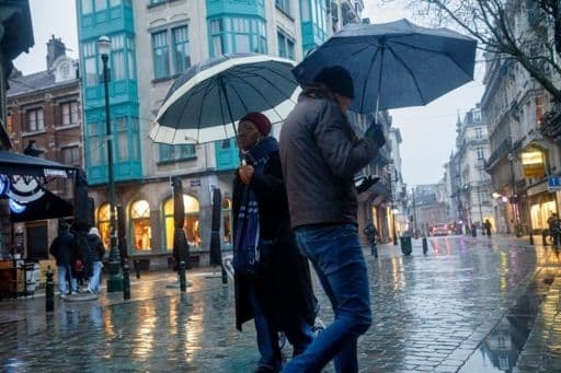
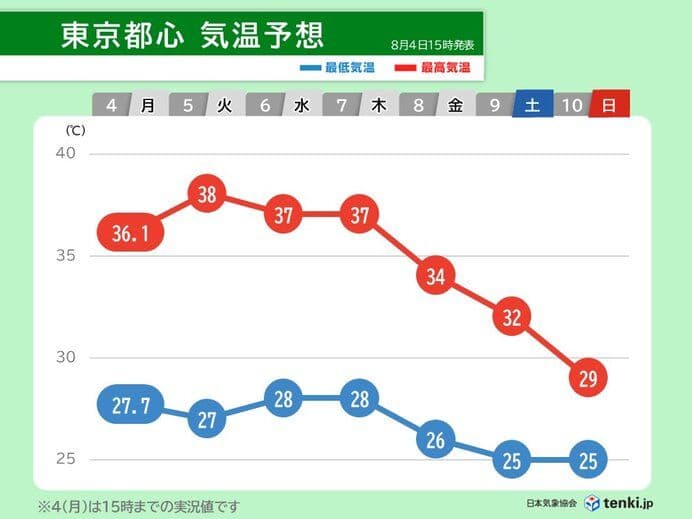
August in often brings a deceptive calm, yet beneath the relentless glare of the summer sun, a powerful atmospheric engine is at work, quietly fueling sudden and dramatic weather shifts. The region, including the sprawling metropolis of Tokyo, has been sweltering under intense heat, with temperatures soaring to a blistering 37.0°C in central Tokyo and even higher in surrounding areas like , Gunma (39.5°C), and , Tokyo (39.3°C). This extreme heat isn't just uncomfortable; it's a critical ingredient for the development of 'rain clouds' (雨雲 - amagumo), transforming the atmosphere into a highly unstable state. As the day progresses and the ground heats up, warm, moist air rises rapidly, creating towering cumulonimbus clouds. It's this vigorous convection that acts as the unseen engine, leading to localized yet potent downpours, often starting around midday. We've already seen instances, such as a localized deluge of 20.0mm per hour in , Tochigi, signaling the start of these intense, heat-driven storms.

Decoding the Deluge: What 'Very Intense Rain' Really Means
When meteorologists issue warnings about 'very intense rain' (hijou ni hageshii ame), it's crucial to understand just what that entails beyond a mere numerical figure. This category typically refers to rainfall rates between 50 and 80 millimeters per hour. Picture a waterfall descending from the sky, accompanied by a roaring sound that makes conversation difficult. At this intensity, a standard umbrella becomes utterly useless; the sheer volume of water overwhelms it instantly. Indoors, in a typical wooden house, the sound and impact are so profound that approximately half of sleeping residents would be jolted awake by the downpour. Driving becomes extremely hazardous, as the dense spray creates a whiteout effect, severely impairing visibility. To put 50mm per hour into perspective, imagine 50 liters of water falling on every square meter of surface, equivalent to 50 milk cartons simultaneously emptying onto an open umbrella. This isn't just heavy rain; it's a force capable of triggering landslides, causing rivers to swell and potentially overflow, and leading to widespread inundation of roads and low-lying areas.

Navigating the Rapid Onslaught: Essential Preparedness for Urban Downpours
The sudden onset and sheer intensity of these urban deluges demand a proactive approach to safety. With warnings of localized heavy rain, floods, lightning, and even hail, residents must quickly adapt. The most immediate concern is road flooding; even seemingly shallow water can conceal dangerous potholes or sweep away vehicles, so it's best to avoid driving through inundated streets. Keep a close eye on local weather advisories and flood warnings, especially if you reside in low-lying areas or near rivers, as these are particularly vulnerable to rapid inundation and potential overflow. Beyond the immediate threat of water, the unstable atmospheric conditions also bring the risk of violent gusts, including small tornadoes, and frequent lightning strikes. If caught outdoors, seek sturdy shelter immediately, away from tall objects and open spaces. For those at home, ensure drains are clear and be prepared for potential power outages. These summer storms often develop and dissipate quickly, but their fleeting nature doesn't diminish their capacity for significant disruption and danger, necessitating constant vigilance and swift action.

The Dynamic Dance of Localized Thunderstorms
The summer atmospheric conditions in the region create a dynamic and often unpredictable weather pattern. It's a delicate balance where intense heat meets abundant moisture, fostering an environment of extreme instability. This isn't a widespread, uniform rainfall; instead, it's a localized 'dance' of individual rain and thunderclouds that can develop rapidly over specific areas, delivering a torrent of water before moving on or dissipating. While itself can experience these downpours, prefectures like , , and are frequently noted for their susceptibility to these "very intense" localized storms, often described as 'waterfalls from the sky.' This localized nature means one area might be experiencing a full-blown deluge with lightning and hail, while a mere few kilometers away, the sun continues to shine. This inherent unpredictability underscores the need for real-time weather updates and radar maps, allowing residents to track the movement of these potent, though often short-lived, weather phenomena. Understanding this dynamic interplay between heat and atmospheric instability is key to appreciating the paradox of Tokyo’s August skies – where scorching days can abruptly transition into torrential, thundering nights.
Related Articles

The Heat's New Frontier: Japan's Scorching Summer Rewrites History
The Heat's New Frontier: Japan's Scorching Summer Rewrites History
Whispers of Thunder: Unpacking Summer's Capricious Storms
Whispers of Thunder: Unpacking Summer's Capricious Storms

Between Deluge and Dog Days: Navigating Hong Kong's August Weather Enigma
Between Deluge and Dog Days: Navigating Hong Kong's August Weather Enigma
The Obon Paradox: When Autumn Whispers Amidst Summer's Fierce Grip