The Roar and the Radar: Navigating the New Era of Severe Thunderstorm Warnings
Navigate severe storm warnings like a pro. Understand thresholds, upgrade your home safety, and discover community resilience strategies for today's intense weather.

The Whispers Before the Tempest
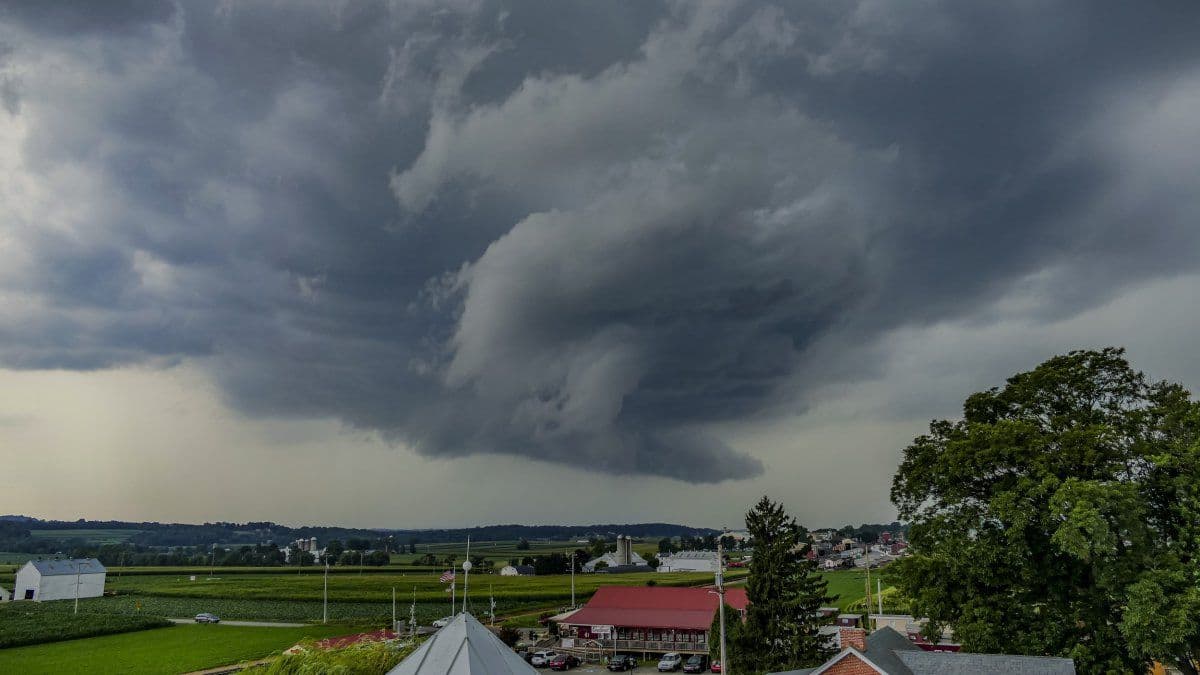
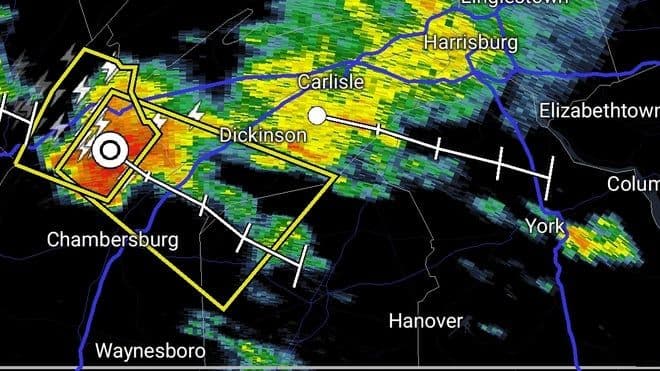
The air hung heavy and thick, a palpable precursor to the volatile energy brewing above. Across and the broader Northeast, an oppressive heat wave had baked the landscape, creating the perfect, unstable atmosphere for nature's fury to unleash. Then, the whispers began – not of wind, but of radar echoes and alerts. Just after 3:20 PM ET, the first Severe Thunderstorm Warning crackled across south-central Pennsylvania, signaling an immediate threat. These weren't distant rumbles; these were 60 mph wind gusts and penny-sized hail, moving swiftly at 35 mph, strong enough to tear at rooftops, fell trees, and disrupt power. “It’s all happening fast,” remarked Raul Martinez, a truck driver caught on , perfectly capturing the sudden, disorienting shift from sun-drenched roadways to dodging fallen branches. The initial warnings, like those issued for Adams County and areas near Carroll Valley, weren't just forecasts; they were urgent calls to attention, indicating that the tempest was not merely approaching, but already arriving, leaving little time for hesitation.
Decoding the Warning: What Those Alerts Really Mean
Understanding a severe thunderstorm warning goes beyond simply knowing bad weather is coming; it's about grasping the specific thresholds and imminent impacts. When the issues a Severe Thunderstorm Warning, as they did for Adams County at 3:31 p.m. or south-central Pennsylvania shortly after 3:20 p.m., it's a critical signal. This isn't just a general advisory; it means a storm is either already producing or is highly likely to produce winds of 58 mph (50 knots) or greater, or hail one inch (quarter-sized) or larger. The recent warnings highlighted wind gusts of 60 mph and penny-sized hail, even though penny-sized hail is technically below the severe threshold, it still indicates a robust storm with potential for localized damage. These winds are strong enough to snap large tree branches, knock over entire trees, and cause significant property damage and injuries. The NWS also stressed the pervasive threat of lightning, urging, “If you can hear thunder, you are close enough to be struck.” And with heavy rainfall, the risk of flash flooding becomes very real, underscored by the life-saving directive: “Turn around, don’t drown.” These specific details empower residents to interpret the warning not as a vague threat, but as a precise indication of danger requiring immediate, informed action.
From Alert to Action: Proactive Preparedness Beyond the Basics
Receiving a severe thunderstorm warning is only the first step; the true measure of resilience lies in how swiftly and effectively one translates that alert into action. Moving beyond common sense, a proactive approach involves understanding the 'why' behind the safety recommendations. For those indoors, staying away from windows and retreating to an interior room on the lowest level, or a basement, isn't just about avoiding flying debris; it's about creating a protective barrier against the storm’s most destructive forces. If caught outside, the urgency to seek immediate, sturdy shelter is paramount. Sheds, tents, and even the seemingly protective canopy of trees offer no real defense against damaging winds or lightning strikes. Even in a vehicle, while safer than being exposed, the advice to avoid parking under trees and to seek a more secure location reflects a deeper understanding of potential hazards. This proactive stance also means leveraging technology: regularly checking forecasts at and ensuring phones are charged are simple yet crucial steps that bridge the gap between knowing and doing, allowing for rapid response as conditions evolve.
Beyond Your Window: Community Resilience and Next-Gen Forecasting
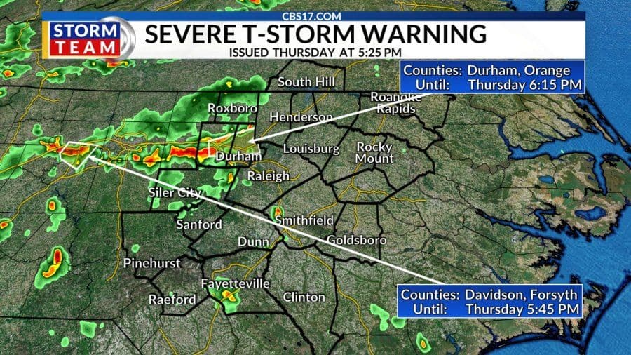
While individual preparedness is vital, the full scope of navigating severe weather extends far beyond one's immediate surroundings, encompassing broader community resilience and the relentless advancement of forecasting. The multi-state Severe Thunderstorm Watch, stretching from to , illustrates the expansive reach of these weather systems and the need for a coordinated, regional response. Emergency services, often the first responders to the storm's aftermath, play a critical role, not just in rescue but in issuing crucial advisories like avoiding flooded roads. The cumulative impact on infrastructure, from major highways like to power lines, underscores the interconnectedness of our communities in the face of nature’s might. This era of increasingly intense weather events demands more than just reacting; it calls for a continuous evolution in how we predict, communicate, and collectively prepare. Next-gen forecasting, fueled by increasingly sophisticated radar technology and predictive models, constantly refines our ability to pinpoint threats and issue more precise warnings, allowing communities to build stronger, more adaptive resilience strategies. It's a dynamic partnership between the science of meteorology and the proactive spirit of every individual and community.
Related Articles
The Silent Scramble: Inside America's Race Against Lightning-Fast Storms
The Silent Scramble: Inside America's Race Against Lightning-Fast Storms
Nature's Urgent Whisper: Mastering the Minutes Before a Severe Thunderstorm Strikes
Nature's Urgent Whisper: Mastering the Minutes Before a Severe Thunderstorm Strikes

When the Sky Roars: Mastering the Critical Minutes of a Severe Thunderstorm Warning
When the Sky Roars: Mastering the Critical Minutes of a Severe Thunderstorm Warning
Living on Alert: Navigating Central NC's Dynamic Weather Reality