Summer Skies Unfiltered: Mastering the Art of Local Weather Wisdom
Navigate summer's unpredictable shifts. Learn how localized storms form, decode DWD warnings, and get essential tips for staying safe and prepared.

Unpacking Summer's Shifting Moods: Beyond the Daily Forecast
Summer arrives with promises of long, sun-drenched days, but anyone who has experienced a typical high-summer knows its moods can shift on a dime. What starts as a bright, clear morning, perhaps with temperatures climbing comfortably into the high 20s or even low 30s Celsius, can quickly transform. The initial sunny skies and dry conditions often give way to building clouds by afternoon, leading to showery rain and even thunderstorms by evening, frequently rolling in from the southwest. This isn't just a minor change; we're talking about the potential for localized severe weather, including intense downpours. The wind, initially gentle, can pick up significantly, especially near these developing storm cells. This rapid transition underscores a crucial point: relying solely on a generic daily forecast often falls short in truly understanding summer's unpredictable nature. It’s about recognizing the atmospheric cues that signal an impending shift, moving beyond simple awareness to a deeper, more actionable understanding of the sky above.

Decoding the Downpour: Anatomy of a Localized Thunderstorm
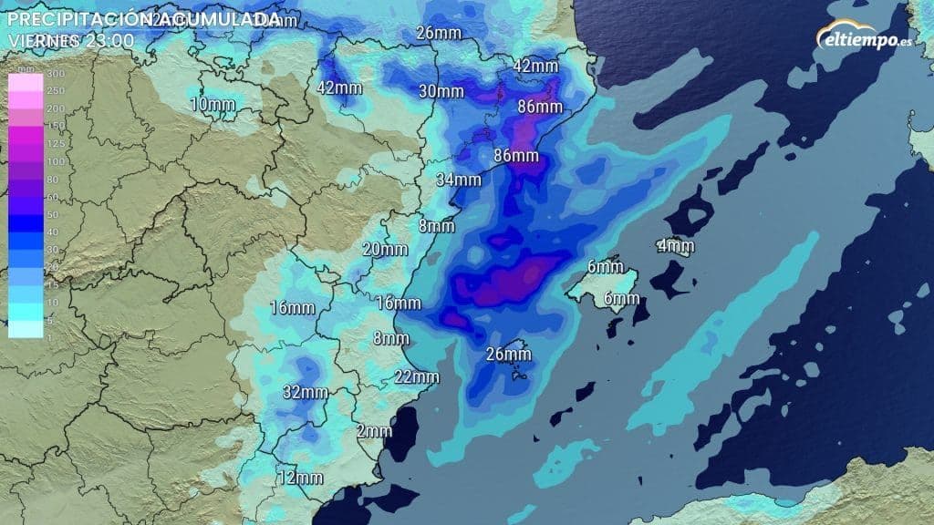
Those sudden, heavy summer rains and booming thunderstorms aren't random occurrences; they're the result of specific atmospheric conditions converging. Often, intense daytime heating, as seen with temperatures soaring to 28 to 32 degrees Celsius, creates a significant amount of instability in the atmosphere. When combined with ample moisture, this instability provides the perfect breeding ground for localized thunderstorms. They typically develop in the afternoon or early evening, growing rapidly from seemingly benign clouds into towering cumulonimbus giants. These 'pop-up' storms are notorious for their concentrated power: a single cell can unleash a staggering 15 liters per square meter of rain in just an hour. This isn't just a heavy shower; it's a deluge that can overwhelm drainage systems and lead to flash flooding in specific areas, even while neighboring towns remain completely dry. Understanding this localized intensity is key to appreciating their potential impact.
When the Wind Whispers of Fury: Understanding Gusts and Severe Weather Alerts
While the heavy rain from localized thunderstorms grabs attention, the accompanying wind can be equally, if not more, dangerous. These aren't just gentle breezes; we're talking about 'sturmböen' – powerful wind gusts that can reach speeds of 60 to 75 kilometers per hour, or even higher. To put that in perspective, 75 km/h is equivalent to a strong gale (Beaufort Force 9), capable of causing significant damage to trees and structures. Weather services like the frequently issue specific warnings for these gusts, often alongside alerts for heavy rain, pinpointing affected cities and regions like , , and the . These alerts aren't just general advisories; they specify the expected wind speeds and the timeframe during which the risk is highest. Learning to interpret these precise warnings, understanding what 'sturmböen' means for your immediate environment, is vital for personal safety and property protection during summer's volatile weather.
Navigating Nature's Whims: Practical Steps for Preparedness
Given summer's penchant for swift, localized weather changes, proactive preparedness becomes paramount. The first, and arguably most crucial, step is to actively monitor official weather warnings from reliable sources. These alerts, often updated hourly, provide specific details about the type of severe weather expected – be it heavy rain, strong wind gusts, or both – and precisely where and when it's most likely to occur. For instance, knowing that a severe thunderstorm warning for your area extends until a certain time allows you to adjust your plans accordingly. Before a storm hits, secure any loose outdoor items like patio furniture or trampolines. During a severe weather event, seek shelter indoors, away from windows, and avoid unnecessary travel. Never underestimate the power of floodwaters or strong winds. By understanding the dynamics of these summer storms and taking these practical precautions, you transition from merely observing the weather to actively safeguarding yourself and your property.
Related Articles

Whispers of Thunder: Unpacking Summer's Capricious Storms
Whispers of Thunder: Unpacking Summer's Capricious Storms
July's Temperamental Turn: Navigating Spain's Unexpected Mediterranean Downpour
July's Temperamental Turn: Navigating Spain's Unexpected Mediterranean Downpour
Nature's Rollercoaster: Understanding Your Local Weather's Wild Swings
Nature's Rollercoaster: Understanding Your Local Weather's Wild Swings

The Volatile Canvas: Navigating Summer's Extreme Heat and Sudden Storms Across China