Decoding the Deluge: How Wipha's Path Unleashes Catastrophic Rains in Northern Vietnam
Uncover Wipha's true danger: not just wind, but relentless, geographically amplified rainfall. Learn why Northern Vietnam faces extreme floods, landslides, and prolonged wet conditions.
Wipha's Unpredictable Dance: Navigating the Gulf of Tonkin
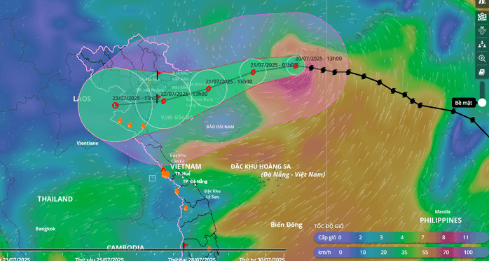
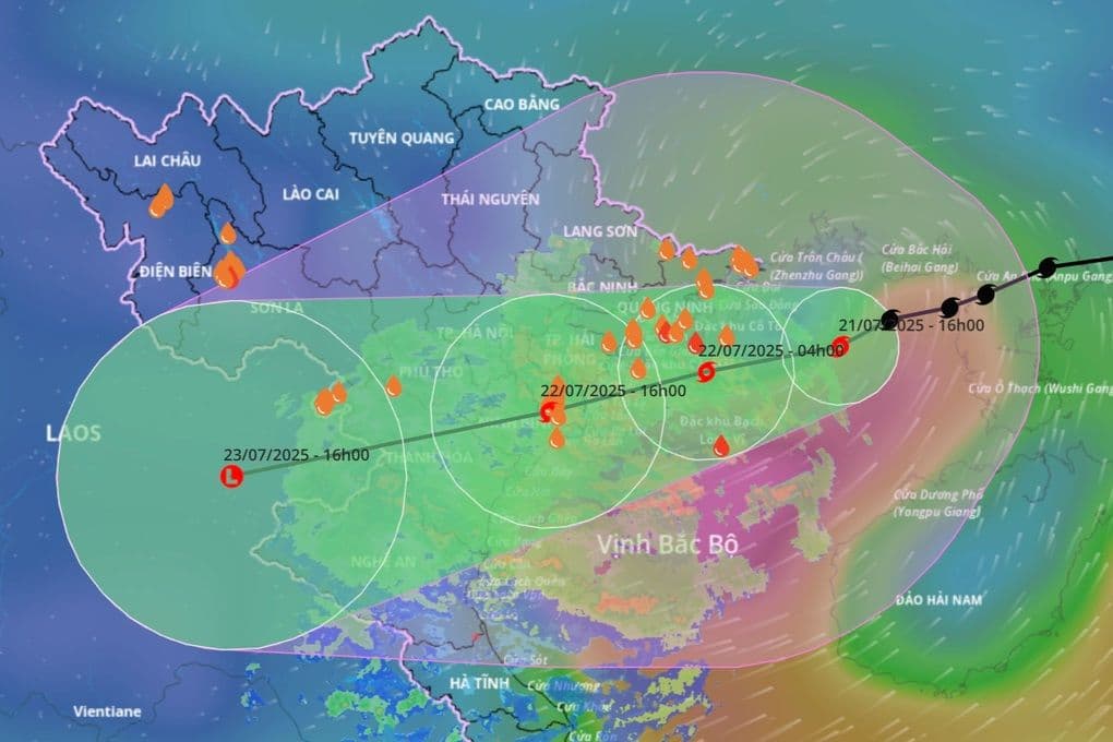
Typhoon , a name now etched into the concerns of , has been performing an unpredictable dance across the . After making landfall in , the storm initially showed signs of slowing as it entered waters early on July 21st. However, that lull was short-lived. In a sudden shift, Wipha accelerated, picking up pace to approximately 15 km/h as it tracked west-northwest. By 10 AM on the 21st, its eye was positioned about 190 km from and 310 km from , with its strongest winds clocking in at Category 9, gusting to Category 11. Forecasters anticipate the typhoon could even intensify further to Category 10-11, with gusts up to Category 14, as it nears the coastal region, potentially maintaining this formidable strength. This dynamic and somewhat erratic trajectory is critical, not just for its immediate wind impact, but for how it positions the storm to unleash a far more insidious threat: relentless, heavy rainfall.
Beyond the Eye: The Torrential Threat of Unprecedented Rainfall
While the immediate concern with any typhoon often leans towards its destructive winds, Wipha's true menace for lies squarely in the sheer volume of water it's poised to deliver. Initial observations show Wipha's cloud cover already blanketing the entire , though the most intense convective rain bands have yet to fully sweep inland, sparing areas like and the from the heaviest downpours for now. However, this is merely the calm before the storm. As Wipha draws closer to the coastline, its cloud organization is expected to stabilize, pushing the heavy rain-producing convective cells directly over land. The most extreme rainfall is projected to occur from tonight into tomorrow morning, with some areas in the Northeast, Red River Delta, , and provinces bracing for a staggering 200-350 mm of rain, and isolated pockets potentially exceeding 600 mm. Other northern provinces and could still see 100-200 mm, with some spots hitting over 300 mm. Such extreme precipitation, with a high risk of more than 150 mm falling within just three hours, transcends typical tropical storm impacts, signaling a widespread and catastrophic deluge.
Mountains and Monsoons: Geography's Role in Amplifying the Deluge
The forecast for such unprecedented rainfall isn't merely a direct consequence of Wipha's strength; it's a stark reminder of unique geographical vulnerabilities. The region's intricate mountainous topography, particularly the '' and the western slopes of the , acts as a formidable amplifier for the storm's moisture-laden air. As Wipha's organized rain clouds encounter these elevated landforms, they are forced upwards, a phenomenon known as orographic lift. This forced ascent cools the air rapidly, leading to intense condensation and the release of massive amounts of moisture. Essentially, the mountains squeeze out the rain from the typhoon's vast cloud system, concentrating it over specific areas. This geographical interaction explains why mountainous regions in and , especially the western slopes of the Truong Son range, are predicted to experience a significant surge in rainfall. It’s a classic example of how a storm's trajectory, when combined with specific terrain, can transform a severe weather event into a potential hydrological disaster.
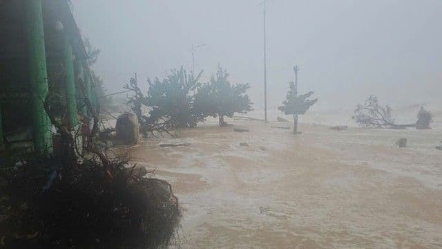
The Cascading Dangers: Widespread Flooding, Flash Floods, and Landslide Risks
The immediate and profound consequence of Wipha's torrential rainfall will be a cascading series of hydrological hazards across . Forecasters warn of widespread inundation in low-lying areas, a high risk of sudden, destructive flash floods in mountainous terrain, and perhaps most critically, the looming threat of landslides. The sheer volume of water, with some areas anticipating over 600 mm, will overwhelm natural drainage systems and quickly saturate the ground. From tonight through July 25th, a significant flood surge of 3-6 meters is expected across rivers in , , and . Smaller rivers, including the and the upper , could reach alarming alert levels two and three. Major arteries like the , , , , , , and upper are also projected to see water levels rise to alert levels one and two, with some potentially exceeding alert level two. The lower reaches of the and , along with the lower Ma and Ca rivers, are expected to hover around alert level one. These rising river levels, combined with the extreme rainfall intensity — over 150 mm in three hours — paint a grim picture of widespread disruption and danger.
A Lingering Shadow: Extended Rainfall and Post-Storm Vigilance
The dangers posed by Typhoon won't dissipate once its eye has passed or its winds subside. A crucial aspect of this weather event is the anticipated 'second wave' of rainfall, a lingering shadow that could exacerbate an already precarious situation. Even after Wipha moves further inland and weakens, perhaps crossing into , and are expected to continue experiencing significant precipitation. This extended period of rain will be driven by the influence of a tropical convergence zone, a broad area where moist air masses converge, leading to sustained cloud formation and rainfall. This means that even as the immediate typhoon threat diminishes, the ground, already saturated by Wipha's initial deluge, will continue to absorb more water. As Ms. from the aptly warned, the risk of landslides, in particular, becomes even higher after the typhoon weakens, when the soil has become thoroughly waterlogged and unstable. This emphasizes the need for prolonged vigilance, as the cumulative impact of the rainfall poses a sustained and multifaceted threat long after Wipha's direct passage.
Related Articles
Wipha's Unseen Architect: Decoding the Unusual Forces Behind Vietnam's Looming Deluge
Wipha's Unseen Architect: Decoding the Unusual Forces Behind Vietnam's Looming Deluge
Wipha's Ascent: Navigating the Multi-Faceted Peril Facing Northern Vietnam
Wipha's Ascent: Navigating the Multi-Faceted Peril Facing Northern Vietnam
Wipha's Deceptive Dance: Unpacking the Enigma of Typhoon No. 3
Wipha's Deceptive Dance: Unpacking the Enigma of Typhoon No. 3
Wipha's Whirling Warning: How Vietnam Faced an Unpredictable Force