Wipha's Unseen Architect: Decoding the Unusual Forces Behind Vietnam's Looming Deluge
Explore Typhoon Wipha's unprecedented threat to Northern Vietnam. Unpack its unique characteristics, extreme rainfall patterns, and the critical insights for preparedness.
A Storm Unlike Others: Wipha's Peculiar Meteorological Profile
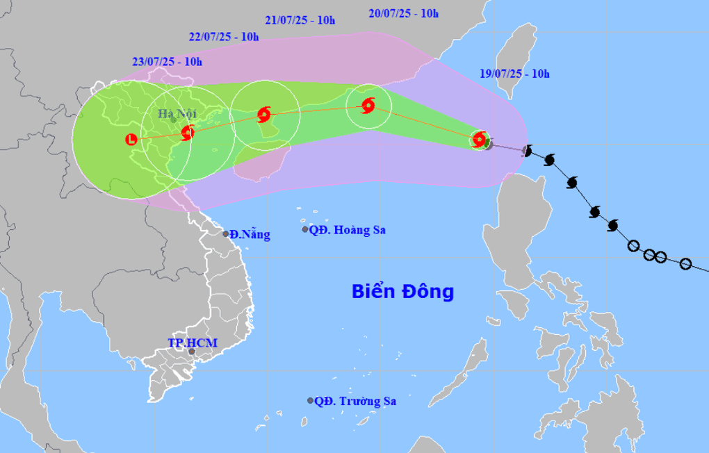
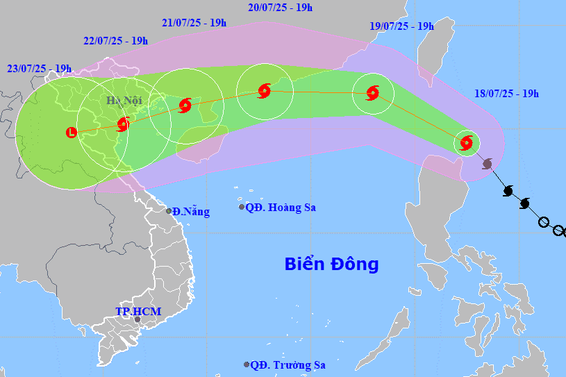
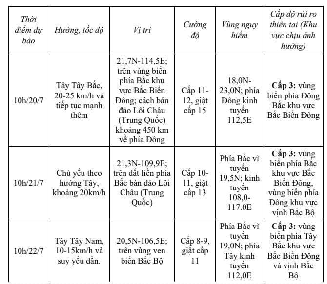
Typhoon , now designated as the third storm of 2025 to enter the , presents a meteorological profile that has forecasters raising eyebrows. What makes Wipha so unusual? According to , Head of the Weather Forecasting Department at the , Wipha is operating in what he describes as an "ideal environment." This isn't just hyperbole; the sea surface temperatures in Wipha's path, and across the northern where it's expected to traverse, hover around a remarkable 30-31 degrees Celsius. Such warmth provides a colossal energy reservoir, fueling the storm's growth. Compounding this, points to minimal wind shear in the upper atmosphere, a crucial factor that allows moisture to accumulate unhindered. This combination acts as a turbocharger, enabling Wipha to intensify rapidly. Indeed, within just 24 hours of entering the , Wipha escalated from Category 9 to Category 10, with predictions of reaching Category 11-12, gusting to 15, as it approaches the . Its swift movement, clocked at approximately 20 km/h, further adds to its peculiar nature, demanding immediate attention.
The Anatomy of the Deluge: Unpacking the Extreme Rainfall and Hazard Risks
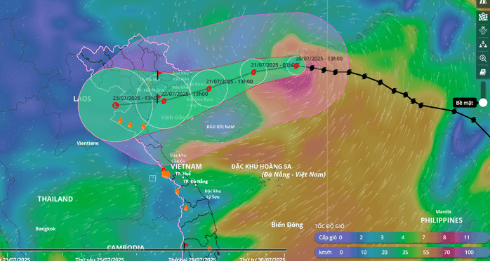
While Wipha's impressive intensification at sea is a concern, its most profound and immediate threat to lies in the sheer volume and distribution of rainfall it's poised to unleash. The 'ideal environment' that allows Wipha to strengthen so dramatically also means it's a massive conveyor belt of moisture. Experts anticipate a period of heavy to very heavy rain across a broad swath of and the , specifically from July 21st to 24th. This includes the midland and delta areas of , along with , , and northern . Beyond the widespread downpours, the potential for localized extreme rainfall is particularly alarming; some areas could see over 150mm of rain within just three hours. Such intense bursts drastically elevate the risk of flash floods and landslides, especially in the vulnerable mountainous terrains of the , , and . The coastal areas from to are also bracing for strong winds, adding another layer of complexity to the impending hazards.
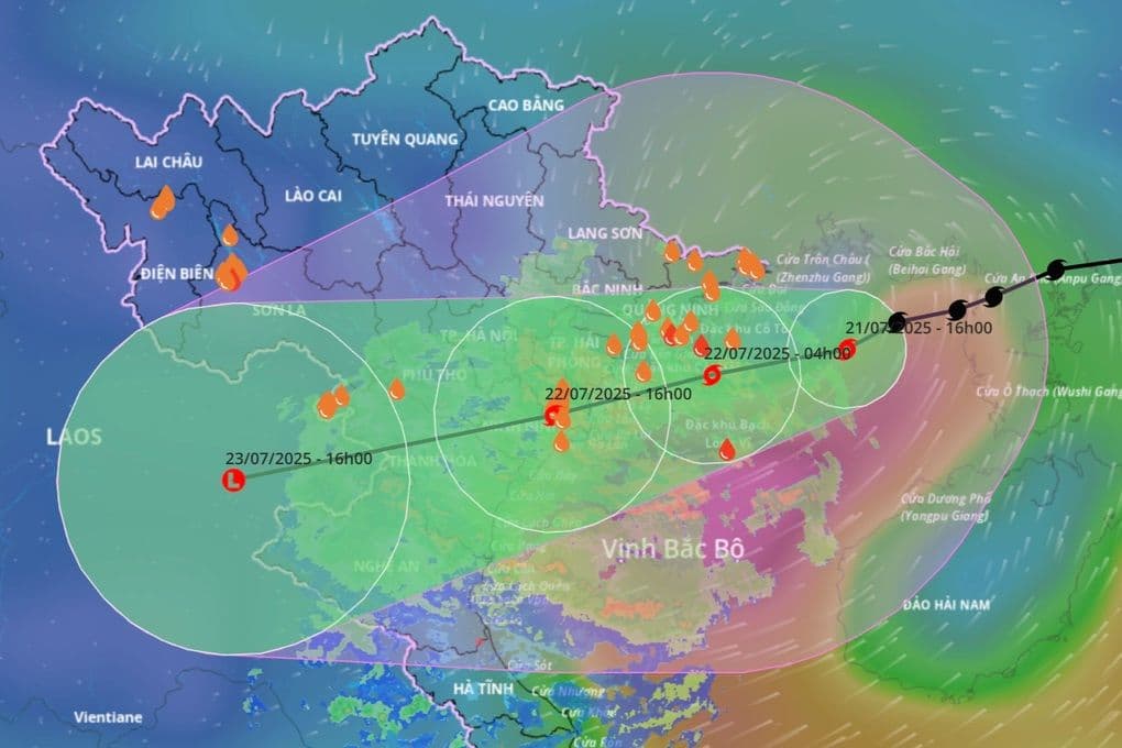
The Unfolding Timeline: Anticipating Wipha's Direct Impact and Progression
Understanding Wipha's timeline is critical for effective preparedness. Having entered the on the morning of July 19th as Storm No. 3, Wipha has been on a relentless westward-northwestward trajectory, accelerating its pace to about 20 km/h. By the morning of July 20th, forecasts indicate it will have reached a formidable Category 11-12, with gusts up to Category 15, positioned roughly 450km east of . The direct impact on is anticipated to begin late on July 21st, extending into the early hours of July 22nd. Coastal provinces from to are expected to feel the initial brunt of strong winds. Following this, the widespread and intense rainfall, as previously outlined, will settle over the northern midlands, delta, , , and northern , persisting through July 24th. The is closely tracking this progression, emphasizing that while Wipha's peak strength might manifest closer to the , its indirect effects on , particularly the prolonged and heavy rainfall, are a significant concern.
Beyond the Forecast: Strategic Preparedness for an Evolving Threat
The unique characteristics of — its rapid intensification, swift movement, and potential for skewed, extreme rainfall — demand a preparedness strategy that goes well beyond a standard forecast. This isn't just about knowing when the rain starts; it's about anticipating an evolving and potentially unpredictable threat. Meteorological agencies are urging residents in and to maintain vigilant monitoring of weather bulletins. The call to action is clear: proactive response is paramount. This includes securing homes, preparing for potential evacuations in flood-prone or landslide-vulnerable areas, and ensuring emergency supplies are at hand. Authorities, too, face a formidable challenge. The is continuously updating its bulletins, providing crucial, real-time data to guide response efforts at all levels of government. With wave heights projected to reach 4-6 meters and violent seas in the northern , maritime operations also require immediate adjustments. As expert wisely advises, overconfidence is a grave mistake in the face of Wipha; the storm's broad impact from to necessitates a unified and agile preparedness across the entire .
Related Articles
Wipha's Ascent: Navigating the Multi-Faceted Peril Facing Northern Vietnam
Wipha's Ascent: Navigating the Multi-Faceted Peril Facing Northern Vietnam
Wipha's Deceptive Dance: Unpacking the Enigma of Typhoon No. 3
Wipha's Deceptive Dance: Unpacking the Enigma of Typhoon No. 3

Decoding the Deluge: How Wipha's Path Unleashes Catastrophic Rains in Northern Vietnam
Decoding the Deluge: How Wipha's Path Unleashes Catastrophic Rains in Northern Vietnam

Wipha's Whirling Warning: How Vietnam Faced an Unpredictable Force