Wipha's Ascent: Navigating the Multi-Faceted Peril Facing Northern Vietnam
Unpacking Typhoon Wipha's escalating peril for Northern Vietnam: From extreme rainfall and dangerous storm surge to vital preparedness strategies.
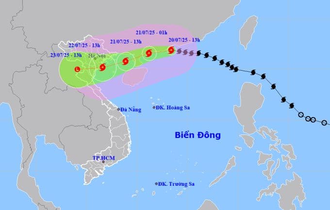
Wipha's Rapid Intensification and Current Trajectory
Typhoon , the third storm to enter the East Sea this year, has taken an alarming turn, defying earlier predictions of weakening as it barrels towards . The reported that as of 13:00 on July 20th, Wipha was positioned approximately 630 km east of . What's particularly concerning is its rapid intensification; within hours, its maximum sustained winds near the eye surged from Level 11 to Level 12, now reaching 133 km/h, with gusts up to Level 15. This acceleration in strength, noted by both and meteorological agencies who concur on its sustained high intensity near the Vietnamese coast, paints a grim picture. Moving westwards at a brisk 20-25 km/h, Wipha is expected to enter the northern by July 21st, maintaining its formidable strength before making landfall along the coastline by July 22nd. This unexpected resilience in its core strength demands immediate attention and a heightened state of alert across the region.
The Unprecedented Deluge: Extreme Rainfall and Flash Flood Risks
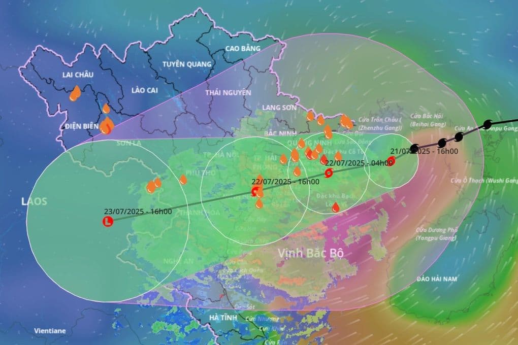
Beyond the immediate wind threat, Wipha carries an even more insidious danger: an unprecedented volume of rainfall poised to inundate . Starting the evening of July 21st and continuing through July 23rd, the region is bracing for widespread heavy rains, with general accumulations expected between 100-200 mm. However, the true peril lies in localized areas, particularly in the Northeast, Northern Delta, , and provinces, where rainfall could soar to a staggering 200-350 mm, with some isolated spots potentially exceeding 600 mm. The meteorological agency has issued urgent warnings about the risk of high-intensity downpours, specifically noting the potential for over 150 mm within a mere three hours. Such extreme rainfall rates significantly elevate the risk of flash floods and dangerous landslides, especially in mountainous and low-lying urban areas. Recalling the tragic impacts of previous storms like in June, which caused 11 fatalities and extensive flooding in , underscores the critical need for communities to prepare for this impending deluge.
Coastal Threats: Storm Surge and Inundation Warnings
As Wipha approaches, coastal communities, particularly in and , face a compounding threat: dangerous storm surges. Forecasts indicate that the storm could generate water levels rising by 0.5 to 0.8 meters along the coastline. This surge, when combined with high tides, will create exceptionally elevated water marks, with in Hai Phong potentially seeing levels up to 4.1 meters and in Quang Ninh reaching up to 5 meters. Such combined effects are predicted to cause significant inundation in low-lying coastal areas and river mouths during the midday and afternoon of July 22nd, precisely when Wipha is expected to make landfall. This dual threat of storm surge and tidal amplification means that coastal populations must not only contend with the direct force of the typhoon but also prepare for widespread flooding that could compromise infrastructure, displace residents, and disrupt critical services. The immediate priority for these vulnerable communities is to secure properties and, if advised, evacuate to higher ground before the full impact of the storm surge arrives.
Winds of Fury: Landfall Impact and Wider Area Hazards
The destructive power of Typhoon extends far beyond its rainfall and coastal surges, bringing with it a formidable onslaught of winds. From the evening of July 21st, inland areas stretching from to will experience a significant escalation in wind speeds, with gusts reaching Level 7-9, and potentially Level 10-11. Closer to the typhoon's eye, winds could intensify further to a devastating Level 10-11, with gusts up to Level 14. Even deeper inland, areas will still contend with strong winds of Level 6-7, gusting up to Level 8-9, capable of causing widespread damage to structures, trees, and power lines. Out at sea, the situation is even more perilous. The northern is already seeing winds of Level 8-10, escalating to Level 11-12 near the eye, with gusts up to Level 15, churning waves to a formidable 5-7 meters. The northern , including vital areas like , , and , will witness winds climbing from Level 6 to a dangerous Level 11, with gusts up to Level 14, and waves reaching 2-4 meters, even higher near the center. All vessels operating in these hazardous zones are at extreme risk and have been urged to seek immediate safe harbor.
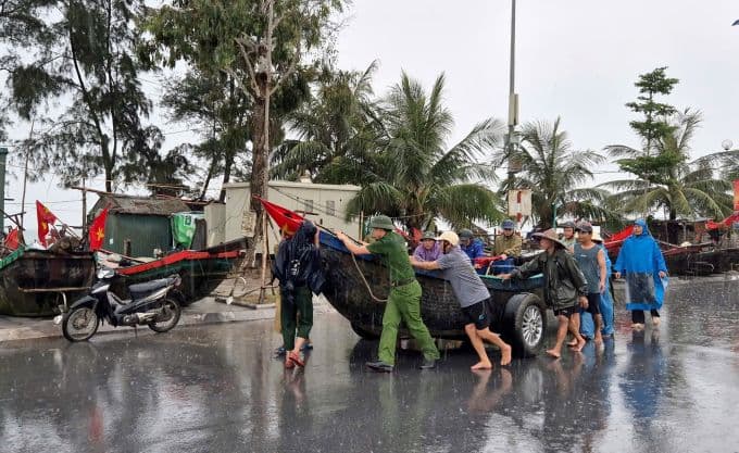
Proactive Measures: A Call to Resilience and Preparedness
The compounding threats posed by Typhoon —from its surprising intensification and destructive winds to the unprecedented rainfall and dangerous storm surges—underscore an urgent call for comprehensive preparedness and collective resilience. Meteorological advancements have provided invaluable early warnings, allowing authorities and communities precious time to enact proactive measures. This isn't merely about issuing alerts; it's about fostering a culture of readiness where every individual understands their role in mitigating disaster. Local authorities are undoubtedly working to ensure evacuation routes are clear, shelters are prepared, and emergency services are on standby. But public response is equally critical. Secure homes, prepare emergency kits, monitor official advisories diligently, and prioritize safety above all else. This moment demands a unified effort, leveraging timely information to protect lives and livelihoods. By acting decisively now, utilizing the foresight provided by modern meteorology, can face Wipha's multi-faceted peril not just with apprehension, but with a strengthened resolve to minimize its devastating impact and emerge more resilient.
Related Articles
Wipha's Unseen Architect: Decoding the Unusual Forces Behind Vietnam's Looming Deluge
Wipha's Unseen Architect: Decoding the Unusual Forces Behind Vietnam's Looming Deluge
Wipha's Deceptive Dance: Unpacking the Enigma of Typhoon No. 3
Wipha's Deceptive Dance: Unpacking the Enigma of Typhoon No. 3
Decoding the Deluge: How Wipha's Path Unleashes Catastrophic Rains in Northern Vietnam
Decoding the Deluge: How Wipha's Path Unleashes Catastrophic Rains in Northern Vietnam
Wipha's Whirling Warning: How Vietnam Faced an Unpredictable Force